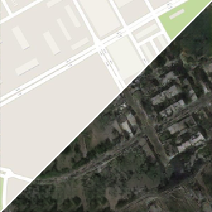
A Model to Translate Satellite Photos and Street Maps
Pix2pix is a conditional adversarial network capable of performing general-purpose image-to-image translation. The architecture enables an efficient aggregation of features of multiple scales through skip connections with concatenations and can be trained on different datasets to perform different translations.
This particular model was trained to generate a street map from a satellite photo and is available in the Wolfram Neural Net Repository. See more details here.
And this other network was was trained to do the reverse. It generates a satellite photo from a street map. See more details here.