| More about Mathematica » |
 |
|  |
| 
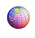
Mathematica 7 adds support for advanced high-precision geodesy, providing a modern foundation for accurate geospatial information and computation. With comprehensive support for all standard reference ellipsoids, datums and projections, Mathematica 7 streamlines the process of importing, combining and computing with geospatial data from varied sources—as well as supporting symbolic geodesy, fully integrated with Mathematica's broad mathematical computation capabilities.
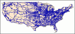
- Import of all common terrain and map file formats. »
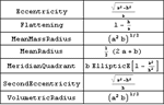
- Comprehensive built-in database of geodetic datums and reference ellipsoids. »
- Geodetic forward and inverse problems. »
- Geographic, ECEF, and local tangential ENU coordinate systems. »
- Full 14-parameter datum transforms, including time dependence. »
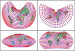
- Extensive built-in library of cartographic projections. »
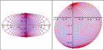
- Spherical and high-precision ellipsoidal projections supported.
- Arbitrary conversions between geodetic and grid coordinates.
- Fully customizable reference ellipsoids, datum and projections.
- Arbitrary precision geodetic computations.
- Exact symbolic and algebraic geodetic computations when possible.
- Integration with built-in city, country and astronomical data.
- Convenient support for DMS and decimal angles. »
- GeoIP-based default location-finding service. »
 |
 |
 |
 |
 |
 |
 |
||
