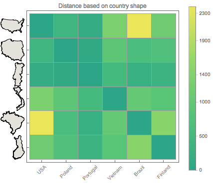
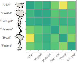
Compare the Shape of Different Countries
Use CanonicalWarpingDistance to find similarity between shapes of different countries.
In[1]:=
names = {"USA", "Poland", "Portugal", "Vietnam", "Brazil",
   "Finland"};
borders = <|# ->
      ArrayResample[CountryData[#, "Polygon"][[1, 1, 1]], 200] & /@
    names|>;
In[2]:=
shapes = Graphics[CountryData[#, "Shape"][[1]],
    ImageSize -> {50, 50}] & /@ Keys[borders]
Out[2]=
Calculate shape distances using canonical time warping.
In[3]:=
dm = DistanceMatrix[Values[borders],
   DistanceFunction -> (Chop[
       CanonicalWarpingDistance[##, MaxIterations -> 6]] &)];
Show the distance matrix.
In[4]:=
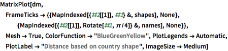
MatrixPlot[dm,
 FrameTicks -> {{MapIndexed[{#2[[1]], #1} &, shapes],
    None}, {MapIndexed[{#2[[1]], Rotate[#1, \[Pi]/4]} &, names],
    None}}, Mesh -> True, ColorFunction -> "BlueGreenYellow",
 PlotLegends -> Automatic,
 PlotLabel -> "Distance based on country shape", ImageSize -> Medium]
Out[4]=