Track a GPS-Equipped Wolf
Make a webpage that shows an up-to-date track of a wolf with a GPS tracking device.
code
CloudDeploy[ExportForm[Rasterize[
GeoGraphics[Line[
Import[
"http://www.wyocoopunit.org/index.php/download_file/662/Smr_\
wntr_poly.kml",
"Data"][[1, 2, 2, 1, 1]]
], ImageMargins -> 50, GeoBackground -> GeoStyling["ReliefMap"],
GeoRangePadding -> \!\(\*
NamespaceBox["LinguisticAssistant",
DynamicModuleBox[{WolframAlphaClient`Private`query$$ = "15 km",
WolframAlphaClient`Private`boxes$$ =
TemplateBox[{"15"}, "QuantityUnit",
DisplayFunction -> (TooltipBox[
StyleBox[
RowBox[{#, " ",
StyleBox[
RowBox[{" ", "\"km\""}], "QuantityUnitTraditionalInput"]}],
ShowStringCharacters -> False], "Unit: kilometers"]& ),
InterpretationFunction -> (RowBox[{"Quantity", "[",
RowBox[{#, ",", "\"Kilometers\""}], "]"}]& ), SyntaxForm -> Mod],
WolframAlphaClient`Private`allassumptions$$ = {},
WolframAlphaClient`Private`assumptions$$ = {},
WolframAlphaClient`Private`open$$ = {1, 2}},
DynamicBox[ToBoxes[
AlphaIntegration`LinguisticAssistantBoxes["", 1,
Dynamic[WolframAlphaClient`Private`query$$],
Dynamic[WolframAlphaClient`Private`boxes$$],
Dynamic[WolframAlphaClient`Private`allassumptions$$],
Dynamic[WolframAlphaClient`Private`assumptions$$],
Dynamic[WolframAlphaClient`Private`open$$]], StandardForm],
ImageSizeCache->{73., {8., 16.}}],
DynamicModuleValues:>{}],
BaseStyle->{Deployed -> True},
DeleteWithContents->True,
Editable->False,
SelectWithContents->True]\), GeoScaleBar -> Automatic]
], "JPEG"], Permissions -> "Public"]
how it works
This pulls GPS data from a website:
Import["http://www.wyocoopunit.org/index.php/download_file/662/Smr_\
wntr_poly.kml", "Data"]
Use Part to select only the tracked points from the data:
gpspts = Import[
"http://www.wyocoopunit.org/index.php/download_file/662/Smr_wntr_\
poly.kml",
"Data"][[1, 2, 2, 1, 1]];
The data is a long GeoPosition list of {latitude, longitude, height} points:
Short[gpspts, 5]
This plots the GPS data on a background of local terrain. Note the use of Ctrl+= to enter natural language units:
GeoGraphics[Point[gpspts], GeoBackground -> GeoStyling["ReliefMap"],
GeoRangePadding -> \!\(\*
NamespaceBox["LinguisticAssistant",
DynamicModuleBox[{WolframAlphaClient`Private`query$$ = "15 km",
WolframAlphaClient`Private`boxes$$ =
TemplateBox[{"15"}, "QuantityUnit",
DisplayFunction -> (TooltipBox[
StyleBox[
RowBox[{#, " ",
StyleBox[
RowBox[{" ", "\"km\""}], "QuantityUnitTraditionalInput"]}],
ShowStringCharacters -> False], "Unit: kilometers"]& ),
InterpretationFunction -> (RowBox[{"Quantity", "[",
RowBox[{#, ",", "\"Kilometers\""}], "]"}]& ), SyntaxForm -> Mod],
WolframAlphaClient`Private`allassumptions$$ = {},
WolframAlphaClient`Private`assumptions$$ = {},
WolframAlphaClient`Private`open$$ = {1, 2}},
DynamicBox[ToBoxes[
AlphaIntegration`LinguisticAssistantBoxes["", 1,
Dynamic[WolframAlphaClient`Private`query$$],
Dynamic[WolframAlphaClient`Private`boxes$$],
Dynamic[WolframAlphaClient`Private`allassumptions$$],
Dynamic[WolframAlphaClient`Private`assumptions$$],
Dynamic[WolframAlphaClient`Private`open$$]], StandardForm],
ImageSizeCache->{76., {8., 16.}}],
DynamicModuleValues:>{}],
BaseStyle->{Deployed -> True},
DeleteWithContents->True,
Editable->False,
SelectWithContents->True]\), GeoScaleBar -> Automatic]
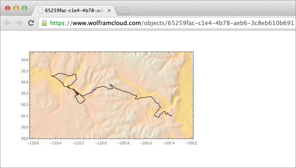
This variation plots the wolf’s movements as a line:
GeoGraphics[Line[gpspts], GeoBackground -> GeoStyling["ReliefMap"],
GeoRangePadding -> \!\(\*
NamespaceBox["LinguisticAssistant",
DynamicModuleBox[{WolframAlphaClient`Private`query$$ = "15 km",
WolframAlphaClient`Private`boxes$$ =
TemplateBox[{"15"}, "QuantityUnit",
DisplayFunction -> (TooltipBox[
StyleBox[
RowBox[{#, " ",
StyleBox[
RowBox[{" ", "\"km\""}], "QuantityUnitTraditionalInput"]}],
ShowStringCharacters -> False], "Unit: kilometers"]& ),
InterpretationFunction -> (RowBox[{"Quantity", "[",
RowBox[{#, ",", "\"Kilometers\""}], "]"}]& ), SyntaxForm -> Mod],
WolframAlphaClient`Private`allassumptions$$ = {},
WolframAlphaClient`Private`assumptions$$ = {},
WolframAlphaClient`Private`open$$ = {1, 2}},
DynamicBox[ToBoxes[
AlphaIntegration`LinguisticAssistantBoxes["", 1,
Dynamic[WolframAlphaClient`Private`query$$],
Dynamic[WolframAlphaClient`Private`boxes$$],
Dynamic[WolframAlphaClient`Private`allassumptions$$],
Dynamic[WolframAlphaClient`Private`assumptions$$],
Dynamic[WolframAlphaClient`Private`open$$]], StandardForm],
ImageSizeCache->{76., {8., 16.}}],
DynamicModuleValues:>{}],
BaseStyle->{Deployed -> True},
DeleteWithContents->True,
Editable->False,
SelectWithContents->True]\), GeoScaleBar -> Automatic]
Deploy the map to the cloud as a jpeg image:
CloudDeploy[ExportForm[Rasterize[
GeoGraphics[Line[
Import[
"http://www.wyocoopunit.org/index.php/download_file/662/Smr_\
wntr_poly.kml",
"Data"][[1, 2, 2, 1, 1, All]]],
ImageMargins -> 50, GeoBackground -> GeoStyling["ReliefMap"],
GeoRangePadding -> \!\(\*
NamespaceBox["LinguisticAssistant",
DynamicModuleBox[{WolframAlphaClient`Private`query$$ = "15 km",
WolframAlphaClient`Private`boxes$$ =
TemplateBox[{"15"}, "QuantityUnit",
DisplayFunction -> (TooltipBox[
StyleBox[
RowBox[{#, " ",
StyleBox[
RowBox[{" ", "\"km\""}], "QuantityUnitTraditionalInput"]}],
ShowStringCharacters -> False], "Unit: kilometers"]& ),
InterpretationFunction -> (RowBox[{"Quantity", "[",
RowBox[{#, ",", "\"Kilometers\""}], "]"}]& ), SyntaxForm -> Mod],
WolframAlphaClient`Private`allassumptions$$ = {},
WolframAlphaClient`Private`assumptions$$ = {},
WolframAlphaClient`Private`open$$ = {1, 2}},
DynamicBox[ToBoxes[
AlphaIntegration`LinguisticAssistantBoxes["", 1,
Dynamic[WolframAlphaClient`Private`query$$],
Dynamic[WolframAlphaClient`Private`boxes$$],
Dynamic[WolframAlphaClient`Private`allassumptions$$],
Dynamic[WolframAlphaClient`Private`assumptions$$],
Dynamic[WolframAlphaClient`Private`open$$]], StandardForm],
ImageSizeCache->{76., {8., 16.}}],
DynamicModuleValues:>{}],
BaseStyle->{Deployed -> True},
DeleteWithContents->True,
Editable->False,
SelectWithContents->True]\), GeoScaleBar -> Automatic]
], "JPEG"], Permissions -> "Public"]
You can produce other visualizations from the raw data, for example, of altitude changes along the wolf’s path and distance traveled over time. Use GeoElevationData to get the altitude in meters and ListLinePlot to plot it.
ListLinePlot[GeoElevationData[gpspts, UnitSystem -> "Metric"],
Filling -> Axis]
Plot the distance traveled using GeoDistance, in miles:
ListLinePlot[
Accumulate[
QuantityMagnitude[GeoDistance @@@ Partition[gpspts[[1]], 2, 1],
"Miles"]]]