Area Distortion by a Projection
The Mercator projection does not preserve areas. It is not an equal-area projection.
Copy to clipboard.
In[1]:=
✖
GeoProjectionData["Mercator", "EqualArea"]Out[1]=
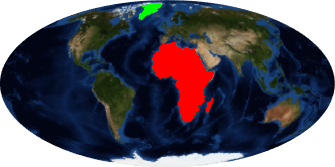
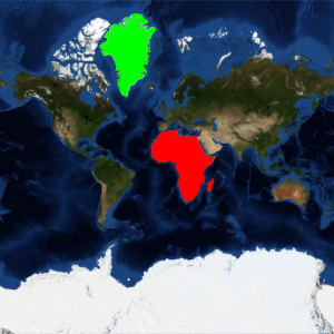
The area of Africa is more than 14 times larger than the area of Greenland.
Copy to clipboard.
In[2]:=
✖
GeoArea[Entity["GeographicRegion", "Africa"]]/
 GeoArea[Entity["Country", "Greenland"]]
Out[2]=
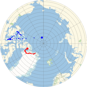
In a Mercator map, however, Africa and Greenland seem to have similar sizes.
Copy to clipboard.
In[3]:=

✖
GeoGraphics[{GeoStyling[Green],
  Polygon[Entity["Country", "Greenland"]], GeoStyling[Red],
  Polygon[Entity["GeographicRegion", "Africa"]]},
 GeoProjection -> "Mercator", GeoRange -> "World",
 GeoBackground -> "Satellite"]
Out[3]=

Use an equal-area projection, like Mollweide, to represent more appropriately the relative sizes.
Copy to clipboard.
In[4]:=
✖
GeoProjectionData["Mollweide", "EqualArea"]Out[4]=
Copy to clipboard.
In[5]:=
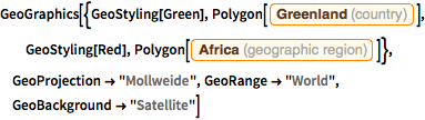
✖
GeoGraphics[{GeoStyling[Green],
  Polygon[Entity["Country", "Greenland"]], GeoStyling[Red],
  Polygon[Entity["GeographicRegion", "Africa"]]},
 GeoProjection -> "Mollweide", GeoRange -> "World",
 GeoBackground -> "Satellite"]
Out[5]=