Спутниковые тайлы Земли
Ниже приведена меркаторская карта Земли, полученная с использованием обработанных спутниковых изображений.
In[1]:=
GeoGraphics["World", GeoProjection -> "Mercator",
 GeoBackground -> "Satellite"]
Out[1]=

Использовать другую проекцию.
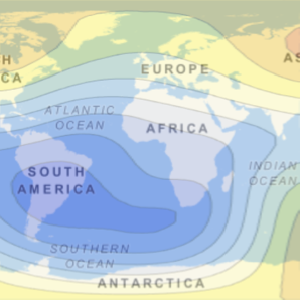
In[2]:=
GeoGraphics["World", GeoProjection -> "Mollweide",
 GeoBackground -> "Satellite"]
Out[2]=

Среднемасштабная карта.
In[3]:=
GeoGraphics[Entity["Country", "Australia"],
 GeoBackground -> "Satellite"]
Out[3]=

Увеличить изображение области вокруг большого города.
In[4]:=
GeoGraphics[Entity["City", {"Sydney", "NewSouthWales", "Australia"}],
 GeoBackground -> "Satellite"]
Out[4]=