火星と冥王星用の新しいタイル
バージョン11には,火星と冥王星のための向上したタイルのセットが加わっている.この例では,火星用の新しいタイルを示す.
火星に着陸した探査機の中から1つ選ぶ.
In[1]:=
probe = Entity["DeepSpaceProbe", "MarsScienceLaboratory"];In[2]:=
{probe["LaunchSite"], probe["LaunchDate"], probe["ArrivalDate"]}Out[2]=
In[3]:=
probe["Image"]Out[3]=

正距円筒図法によるズームレベル1の火星地図上に,着陸地点を示す.
In[4]:=
GeoGraphics[GeoMarker[probe], GeoRange -> All]Out[4]=

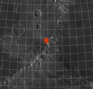
ズームレベルを手動で4に上げる.
In[5]:=
GeoGraphics[GeoMarker[probe], GeoZoomLevel -> 4]Out[5]=

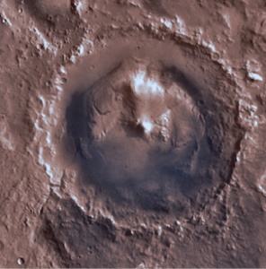
ズームレベルをさらに上げると,画像の中心がゲールクレーターになる.
In[6]:=

GeoGraphics[GeoMarker[probe], GeoZoomLevel -> 4];
Show[%, GeoCenter -> Entity["SolarSystemFeature", "GaleMars"],
 GeoRange -> Quantity[100, "Kilometers"]]
Out[6]=